


Why is it called the Graveyard of the Atlantic?
David Stick, a legendary Outer Banks author, and historian, coined “Graveyard of the Atlantic” in his 1952 book of that name. No one knows how many ships have gone to a watery grave off the coast of North Carolina. Estimates put that figure at somewhere between 2000-5000, although it’s probably closer to the lower figure.
Most historians feel the first ship to slip beneath the waters was a Spanish brigantine off Cape Fear in June of 1526. The ship was part a doomed attempt by Spanish nobleman Lucas Vasquez de Alyson to establish a colony in what is now South Carolina.
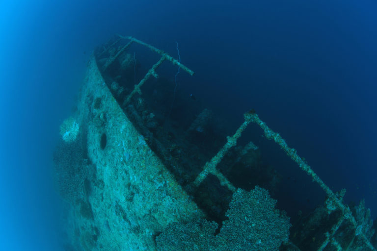
Of all the thousands of ships that came to lie upon the ocean floor off the North Carolina coast, very few have names or are remembered. They sank for a variety of reasons—sailing into uncharted waters, weather, errors in navigation, and war.
Some of the ships do have names—the Metropolis and USS Huron sank off the Outer Banks in the winter of 1877-1878. The incompetence and mismanagement of the Lifesaving Service, who was supposed to be responsible for the rescue of the passengers and crews, was so flagrant that the public outcry forced the federal government to establish professional standards, leading eventually to the US Coast Guard.
The horrors of war were visited to the shores of the Outer Banks in WWI and WWII, and the story of the British tanker Mirlo, sunk by a German mine in August of 1918 is a remarkable tale of heroism by the Lifesaving Service crew at Chicamacomico.
Ships still struggle at times off the coast, although with modern navigation tools and communication, a ship sinking is almost unheard of today.
What, though, are the ingredients that have created the Graveyard of the Atlantic? Why is it that so many ships have foundered between the beaches of Corolla and Ocracoke and even farther south?
What’s Happening at Sea
The Outer Banks—and more properly the coast of North Carolina from the Virginia state line to Cape Fear—exists in an environment unlike any other. Just off its beaches, the Labrador Current and the Gulf Stream collide. Both are powerful, but the Gulf Stream dwarfs the power of almost all other ocean currents transporting the equivalent of 85 times more water than all the freshwater rivers in the world as it passes Cape Hatteras.
That collision can create rough seas and fog.
By itself, that probably would not be enough to send thousands of ships to the Atlantic Ocean floor. But, coupled with the rough seas, reduced visibility, and powerful currents, the geography of the Outer Banks creates a danger all its own.
Diamond Shoals are a series of constantly shifting sandbars extending about 10 miles into the Atlantic Ocean from Cape Hatteras. In clear weather, they are usually easily identified with waves breaking over the shallow water. And it gets very shallow…3’ in some cases.
During a storm or foggy conditions, they become hidden dangers, waiting to capture a ship and hold it for the waves to batter into submission.
Diamond Shoals, although the best known of the Outer Banks shoals, is not the only one.
Wimble Shoals is off Rodanthe, and Platt Shoal is just north of that. Oregon Shoal is off Oregon Inlet, and Kinakeet Shoals are just north of Cape Hatteras.
What the Outer Banks represented in the days of sailing ships was 100 miles of sheer terror when the wind freshened as a storm formed and the seas started to rise.
Why did they sail so close to land?
It didn’t take long for European ship captains and navigators to figure out the coast of North Carolina was dangerous. Yet, they continued to sail close to the shore—in fact, ships continue to sail parallel to the coast to this day.
Which begs the question, why?
The shortest route from Europe to North America may be a direct east to west line, but it is not the fastest route, especially in the days of wind power.
European sailors learned quickly that they could pick up the Canaries Current, a south-flowing current off Europe, ride with it until they got to the west flowing Equatorial Current and then pick up the Gulf Stream around the Bahamas. Even today, ships use the power of the ocean currents as the most efficient way to navigate the seas.
The north-flowing direction of the Gulf Stream was not the only reason mariners would hug the coast.
As the population of the Americas expanded, more and more merchandise was shipped between the Caribbean, South American, and US ports. The fastest and most direct route was—and still is—hugging the shoreline. And at a time when navigational tools were still in their infancy, being able to identify landmarks enabled navigators to mark their passage.
The evidence of those voyages exists beneath the waves. Many, if not most, of the ships that sank in the Graveyard of the Atlantic in the 18th, 19th and 20th centuries were carrying goods and people between American ports. The Metropolis is an example this — its destination Brazil when it sank in 1878.
The list of known wrecks off of the Outer Banks continues to grow as marine archeologists and scientists deploy ever more sensitive equipment. And as the list of ships grows the legend of the Graveyard of the Atlantic continues to be a part of Outer Banks lore.