Moor Shore Road in Kitty Hawk is perhaps a half mile long at the most. A pretty road, it begins at its north end at Kitty Hawk Road, passes some of the original properties of the town, and parallels Kitty Hawk Bay, ending at its south end at Beacon Drive. There is a multi-use path that continues south along the Kitty Hawk Bay shoreline, connecting to Bay Drive and Kill Devil Hills.
The road isn’t used too much; locals use it to bypass the Bypass from time to time, and there are people who live along it, but there is nothing to suggest it is anything other than a quiet, somewhat forgotten, residential street.
That quiet, residential street, though, may have as much historic value as any other road or highway on the Outer Banks. Moor Shore Road was the original way to get from Kitty Hawk to Kill Devil Hills and Nags Head.
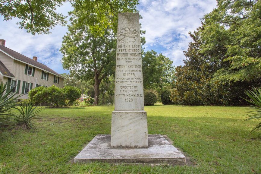
This is the road the Wright Brothers would have used to travel from Bill Tate’s Kitty Hawk house to their Kill Devil Hills campsite (Tate was the Kitty Hawk postmaster at the time, and played a role in helping the Wright Brother’s when they initially arrived on the Outer Banks). There is a marker along the road that reads, “On this site, the Wright Brothers flew their first glider,” that marks where the Tate house once stood. The house no longer stands. Almost all of the 1900 era homes on the Outer Banks were simple clapboard construction, and few if any of those homes have survived.
To understand why Moor Shore would have been the road connecting the Outer Banks towns 100 years ago is to understand life on the Outer Banks at the turn of the 20th century.
The only people who lived on the Atlantic Ocean side of the Outer Banks were crews manning the lifesaving stations that lined the coast. What passed for population centers were small villages huddled along the soundside. When the Wright Brothers arrived in 1900, the population of Kitty Hawk was around 250; Kill Devil Hills had a smattering of homes.
The largest beach town was certainly Nags Head with its well-established summer tourist season. The 1900 Census Bureau population of the town was 1572, although it’s unclear how far north and south the borders of the township extended.
The road that connected the beach towns was Moor Shore Road. It was not always just a half-mile long. As recently as 2000, the multi-use path at the intersection with Beacon Drive was a dirt road that gave access to Windgrass, connecting that to Bay Drive.
As an interesting footnote to this, the Outer Banks Marathon route almost certainly is the 100 year old way to get from Kitty Hawk to Nags Head.
Old maps show a road that is now Bay Drive connecting with a road through Nags Head Woods—a road that can only be Old Nags Head Woods Road.
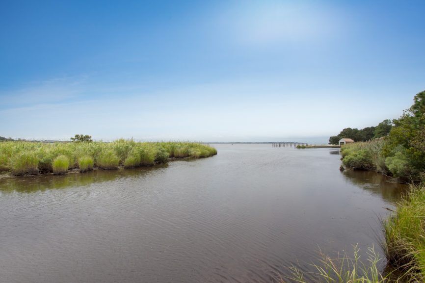
But the Outer Banks is a dynamic environment and the waters of Albemarle Sound have been steadily encroaching upon the Kitty Hawk Bay shoreline. More than 20 miles north of Oregon Inlet and protected by the islands and headlands of the sound, Kitty Hawk Bay is not effected by ocean tides. It is, however, susceptible to wind tides—wind driven water pushed by strong winds.
The result is that Moor Shore Road regularly floods during storm events that carry a west to southwest wind.
There are a number of reasons that engineers looking at the situation point to for the encroachment—an incremental increase in sea level rise, shoreline erosion and loss of subaquatic vegetation. Whatever the driving force or forces are, Moor Shore Road is threatened.
There is an innovative plan on the books as a way to save the road.
In April of this year, representatives of the North Carolina Coastal Federation proposed creating a living shoreline along the most threatened section of the road. The plan called for matching funds from the Town of Kitty Hawk and in June the town council gave approval to spend up to $275,000 to support the project.
The Moor Shore Road project, which will be 850’ long, will use rock sills and living breakwaters to dissipate wave energy as it enters the bay. The sills and breakwaters used for this kind of project are low-lying structures, barely above the level of the water. Although parallel to the shoreline, they are not continuous allowing wave energy to gradually diminish.
That is an important distinction from bulkheads that stop the wave action, but do not diminish the energy in the wave. Because the wave energy in bulkheads is moved but not diminished, bulkheads are often undercut or adjacent lands and properties damaged.
With the diminished wave energy, studies have consistently shown that subaquatic vegetation (SAV) will regrow. SAV’s are the primary food of migratory waterfowl and will dissipate wave energy.
A living shoreline does require a major CAMA permit, and the project is currently under review.