The Wright Brothers Memorial atop Big Kill Devil Hill towers over the site of the Wright Brothers’ first flight and is an iconic symbol of American ingenuity. Located in the heart of the most developed area of the Outer Banks, it makes an ideal focal point for a fairly easy bike ride. These rides are suitable for almost any kind of bike.
We’re going to suggest two rides that use the Memorial as its destination, beginning either from the south side or north. The distances are for a round trip, so the Memorial is the halfway point. The distances are approximate.
For both rides, we enter the park at First Flight Airport.
A quick tip for any ride on the Outer Banks. Whenever possible begin your ride pedaling into the wind. That gentle 10 mph following breeze becomes a test of will when riding into it for a few miles, especially at the end of a ride.
Wright Brothers Monument from Nags Head
Distance: 8-8.5 miles
Starting point: Dowdy Park, Nags Head
This is the shortest and easiest ride of the two rides we’re suggesting and it should be suitable for riders of any age if the rider can handle an 8-8.5 mile ride.
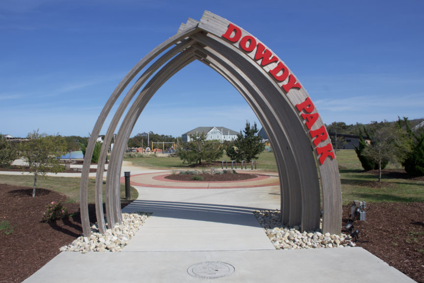
Dowdy Park is located at the intersection of Croatan Highway (the Bypass) and E. Bonnet Street. It has a covered picnic area, a children’s playground, and is designed for outdoor gatherings. When there is not a planned activity, parking is not a problem. During the summer there is a weekly farmer’s market, and throughout the year other activities take place at the park.
From Dowdy Park, turn right (east) and head toward the beach. Nags Head and Kill Devil Hills have well-developed and maintained multi-use paths paralleling Virginia Dare (Beach Road).
Turn left onto the Beach Road.
This is a straight shot along the Beach Road and it’s quite pleasant. There will be an occasional glimpse of the ocean on the right. Follow the path for 2.9 miles to the light at Ocean Boulevard. The Kill Devil Hills Beach Access will be on the right and Stop and Shop on the left.
The sidewalk is on the south or left side of Ocean Boulevard. After crossing the Bypass, Ocean Boulevard becomes Colington Road and at the next light, cross Veterans Drive, then continue on Colington Road to get on the multi-use path to First Flight Airfield. This sounds complicated, but it’s really not.
About a half-mile along Colington Road there will be an access road on the right to the airport.
At the Wright Brother Memorial
There is a sidewalk around the parking tarmac for aircraft. It may be necessary to walk your bike around—it’s a bit narrow and there is a 90-degree turn. But it’s very short and it leads to the road that circles the monument…which is the whole point of the ride.
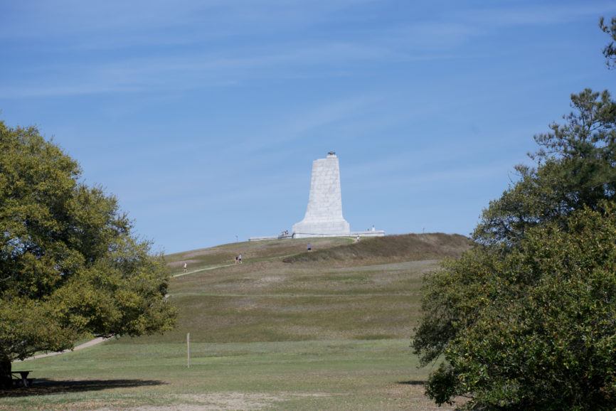
The Loop Road that circles the base of the hill is about a mile long. On the south side of the road, there is North Carolina sculptor Stephen Smith’s recreation of the first flight. Donated to the National Park Service in 2003, it’s a great spot for a quick break.
There are also picnic tables on the north side of the Loop by the short road leading to First Flight Airfield.
When leaving either retrace your steps or exit the park at the main entrance and cross at the light onto Prospect Avenue. Turn right onto the Beach Road at the end of the street.
Retrace the route to return to Dowdy Park.
Wright Brothers Monument from Kitty Hawk
Distance: 12-12.5 miles
Starting point: Kitty Hawk Park, Kitty Hawk
This ride is a longer and more challenging than the Dowdy Park route but offers a greater variety of scenery, a little more history, and an optional Beach Road leg that can be added to the journey.
Kitty Hawk Park is located on Kitty Hawk Road. Part of the Dare County Park System, it includes a skate park, dog park, and access to the Kitty Hawk Woods Birch Lane Trail.
Leaving the park, turn left onto Kitty Hawk Road. The wide shoulder is designed as a bike path, and it is an easy ride.
At Moor Shore Road, the first road past Kitty Hawk United Methodist Church, turn right.
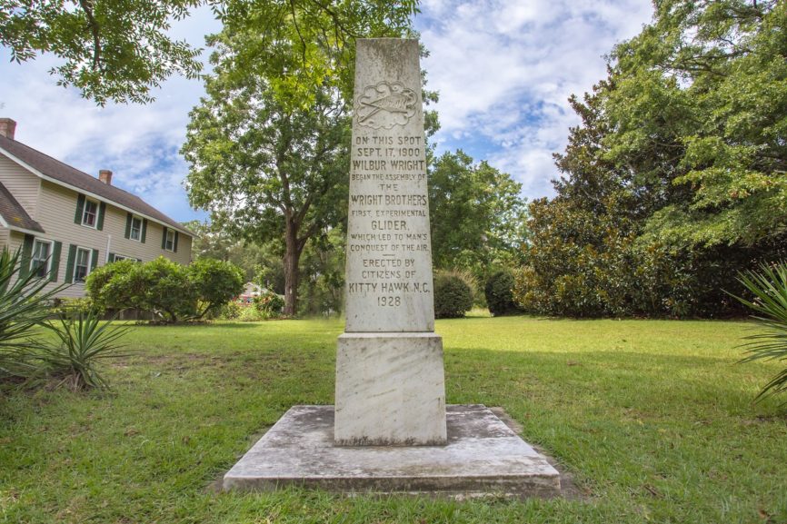
Moor Shore Road is one of the oldest named roads on the Outer Banks and pedaling this road takes riders along the path Orville and Wilbur took to their test site when they first arrived in Kitty Hawk in 1900. Proof of that is the commemorative obelisk marking where Bill and Addy Tate’s house was located. Bill Tate’s letter to the Wright Brothers extolling the attributes of Kitty Hawk for their experiments is what brought them to the Outer Banks.
After passing through a short residential area, the road crosses a bridge and parallels Kitty Hawk Bay. In the summer look for the osprey nest on top of the pole just off the shoreline.
Moor Shore ends at the Wright Brothers Multi-use Path (at one time it was part of Moor Shore Road), a half-mile concrete path that ends at Windgrass Circle. There is a short and briefly challenging climb to the top of the hill that leads to Tateway Rd.
Turn right onto Tateway. Tateway will become Bay Drive as it descends the hill and becomes part of Kill Devil Hills.
This section is a nice wide multi-use path, about 2.2 miles long. For most of the ride, Kitty Hawk Bay is on the right. At Indian Drive, the road will bend to the left and become Canal Drive. Nothing has to be done, the path simply continues.
At the first intersection after Bay Drive becomes Canal Drive, turn right. That is West 1st Street. The multi-use trail continues along West 1st to the end of the road. The multi-use path then continues on a trail that is on the left side of the cul-de-sac where the road ends. It’s very clearly marked.
The path will exit from the trees that form the southwest boundary of the Wright Brothers Memorial property at Colington Road. Stay on the path as it bends to the left. The entrance to First Flight Airfield will be on the left in about a quarter-mile.
An Alternative Return Route
When leaving there is a choice to be made. Either retrace the route, or exit at the main entrance to the Memorial. At the light proceed straight onto Prospect Avenue and then turn left at the Beach Road.
Stay on the Beach Road for 3.5 miles until East Kitty Hawk Road. The Black Pelican Restaurant will be on the left—an easily seen point of reference.
Stay on East Kitty Hawk Road and cross at the light at the Kitty Hawk Post Office and East Kitty Hawk Road becomes West Kitty Hawk Road after the Bypass. Kitty Hawk Park will be on the right in about a mile.
Important note on this option. In the town of Kitty Hawk, the shoulder of the Beach Road is narrow and often sand covered. It is not suitable for an inexperienced or younger rider.
One more tip for bike riders. Be sure to take water with you on either of these options.
Have fun!